Value vector
The Opportunities of Location Intelligence
Sandra Mueller

Anyone who works in the smart city space knows the power of data: it’s held up as rich oil that can be revealed through smart sensor technology embedded throughout the public landscape including train stations, parks and recreation areas in various neighborhoods or districts. It intersects across multiple components of a city including traffic management, public safety, infrastructure and city planning. IoT sensor technologies, cloud ingestion and streaming analytics services enable location data to be collected and analyzed in real-time from connected devices.
Geo-spatial analysis can provide unique insights, revealing previously hidden patterns and relationships that drive stronger decision-making for businesses. Fed by spatial analytics and real-time data, location technology’s applications are broad, ranging from optimizing supply chain management to using real-time asset tracking for logistics to customer analytics in retail. This article takes a look at a variety of use cases and the benefits generated.
Economic Opportunity
Mapping can also provide predictive analytics to aid smart city planning. For example, location intelligence can predict the economic impact of closing traffic in a street and how it affects locals and tourists. It can also determine how it will change commute times, and the number of cars that typically frequent a particular route. Further, it can help determine routes where more public transport may be beneficial in efforts to reduce traffic pollution and provide insight for a business that may want to locate themselves in that area.
Financial institutions such as banks can utilize transactional data record to share with a business owner to decide where are the best places to open, consolidate, or close locations for their business, based on revenue and profitability. They also can gain crucial insight into their competition such as the demographic and socioeconomic factors that have the most significant impact on the success of their and their competitors’ locations. Imagine if you ran a business in a tourist area and you were able to discover how many transactions done by day, by locals or tourists vs. another day? Or what countries tourists are coming from- not only to your city but your suburb, based on anonymized data of credit card transactions?
An interesting example shared by Bernard Marr at this year's PTC LiveWorx detailed a butcher's shop in London that was struggling with sales due to the demise of the high street and the draw of big supermarkets. Wanting to understand their current and potential customers better, they used a tracker to monitor the rate and peak times of footfall outside the shop and were surprised to discover that the most significant traveling route was in the late evening when people were heading to and returning from nightclubs. They applied for a license to sell gourmet barbeque during this time and today make over half their day's earnings in a single hour.
Civic services and city planning

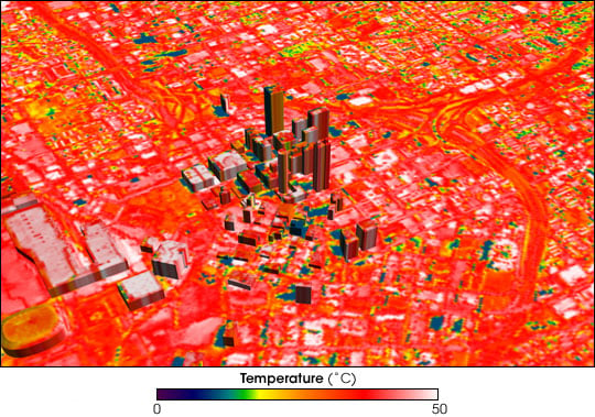
Local governments are increasingly relying on spatially-aware IoT sensors and mobile trace data to monitor urban environments like traffic flows and air quality in real time. Mapping of sensor data can reveal proximity relationships that can also expose macro-scale patterns such as urban heat islands where man-made urban surfaces (such as concrete and asphalt) lead to increased heating of the surrounding area. UHIs are linked to respiratory health conditions, high energy consumption, and pollution. Monitoring these locations and their residents can assist local authorities to identify buildings and communities vulnerable to heat waves such as the homeless and the elderly, and provide the impetus for mitigation strategies.
City engineers can use traffic flow patterns from both embedded street sensors and social media to control traffic signals as well as detecting available parking spaces leading to a reduction in congestion during peak travel times along roads and city streets.
Location intelligence is imperative in planning. For example, spatial analysis can show where people are congregated, and where bike routes and bikes shares should be located to help people access dense residential and business areas. Similarly, businesses such as startups running Electric Vehicle changing stations can utilize local intelligence to map out where they should place EV charging stations, based on proximity to points of interest, population density, and demographic information.
Want to talk further about how technology can benefit cities now and in the future? Momenta is proud to be attending this year's IoT Solutions World Congress in Barcelona where will we be participating and chairing sessions on a range of topics including:
- Why Edge First in Oil & Gas?
- How to survive machine automation and atttract new skilled workers
- Critical Enablers: Edge/Fog Technologies and Applications
- Blockchain technology in Renewable Energy
- Startups in IoT
Make a time to connect with us and find out more.
![]()


